Air Masses and Fronts
Weather- short term variations in atmospheric phenomena that interact and affect the environment and life on Earth are called weather.
Climate- the long-term average of variations in weather for a particular area
Imbalanced heating- temperatures may vary from location to location at a certain time of year is that the Earth's axis of rotation is tilted relative tilt the plane of Earth's orbit. Solar radiation is unequal partly due to the changing angle of incidence of sunlight. The greater the area covered by solar radiation the smaller the amount of heat per unit
Thermal Energy Redistribution- The constant movement of air and water redistributes thermal energy around the world. Weather is part of the constant redistribution of Earth's thermal energy
Air Masses- large volume of air that has the same characteristics, such as humidity and temperature , as its source region.
Source Region- Area over which an air mass forms
1.The origins of Maritime Tropical Air are tropical bodies of water.2. The southwestern US and Mex are source regions of Continental Tropical Air, which is hot and dry, especially.3. Maritime Polar air masses form over the colder waters of the North Atlantic and North Pacific.4. Continental Polar air masses form over the interior of Canada and Alaska, and carries frigid air southward in the winter.5. Earth's ice and snow covered surfaces above 60 degrees north latitude in Siberia and the Artic Basin are the source regions of Artic air masses
Air Mass Modification - When an air mass travels over land or water that has characteristics different from those of its source region, the air mass can acquire some of the characteristics of that land or water and undergo modification
Systems and Air Masses
Coriolis effect- The directions of Earth’s winds are influenced by Earth’s rotation.
This Coriolis effect results in fluids and objects moving in an apparent curved path rather than a straight line
1. Polar Easterlies- wind zones between 60 degrees N latitude and the North Pole and 60 S latitude and the South Pole
2. Prevailing westerlies are wind systems on earth located between latitudes 30 N and 60 N and 30 S and 60 S
3. Trade Winds- between 30 N and the equator is a circulation belt of wind known as trade winds. Trade winds from the North and South meet and join near the equator. The air is forced upward, which creates an air of high pressure. This results in a belt of weak surface winds called the horse latitudes
Jet Stream- narrow band of fast, high- altitude , westerly wind
A collision of two air masses forms a front- a narrow region between two air masses of different densities
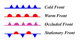
Cold front- when cold , dense airt displaces warm air, it forces the warm air which is less dense up along a steep slope. (intense percipitation)
Warm Front- Advancing warm air displaces cold air along with a warm front. A warm front develops a gradual boundary ( light widesprerad rain)
Stationary Front- When two air masses meet but neither advances, the boundary between then stalls,. This station front frequently occurs between two modified air masses that have small temp. and pressure gradients between them. Sometimes light winds and precipitation.
Occluded Front- Sometimes, a cold air mass moves so rapidly that it overtakes a warm front and forces the warm air upwards. As the warm air is lifted, the advancing cold air mass collides with the cold air mass in front of the warm front. A warm air mass is squeezed upward between two cold air masses. Strong winds and heavy precipitation.
Webquest

Earth Science Wind/Pressure/Weather WebQuest
Part 1. Air Masses
1. http://en.wikipedia.org/wiki/Air_mass Find out what an air mass is.
a. What is an airmass? An airmass is a volume of air defined by its temperature and water vapor content
b. Explain the difference between a “continental(c) ” air mass, and a “maritime(m)” air mass. Continental is dry and Maritime is wet
c. Explain the difference between a “polar(P)” air mass and a “tropical(T)” air mass.
Polar is cold and tropical is wet
2. They describe an air mass by its Moisture content and Temperature, so each air mass has two letters. Name each air mass and describe it by moisture content and temperature.
cP = continental Polar (dry and cold) cT = continental Tropical (dry and warm)
mP =maritime Polar ( wet and cold) mT = maritime Tropical (wet and warm)
Using the map on the webpage, label each of the bubbles below
.
1. Three air masses affect Pennsylvania’s weather the most. Name their air mass symbols and tell me where they come from.
mP from the North East, mT from the South, and cP from the North West
2. Go to the website: http://www.weatherquestions.com/What_causes_high_pressure.htm to find out what causes a high pressure air mass.
a. What causes an air mass to have a high pressure? More atmosphere due to cooling
3. The website http://www.weatherquestions.com/What_causes_low_pressure.htm will help you answer the following question:
a. What causes an air mass to have a low pressure?
Less atmosphere due to atmospheric circulations. Happens along warm-cool boundaries. Air can also be warmed by condensation of water vapor
4. Look at this picture: http://www.physicalgeography.net/fundamentals/images/thermal2.GIF. Does air move from high pressure to low, or low to high? High to Low
Part 2. Global Winds
5. http://ww2010.atmos.uiuc.edu/(Gh)/wwhlpr/global_winds.rxml What are the Global Winds? General Circulation Patterns Label B – L in the diagram below.
Part 3. Coriolis Effect
6. The Coriolis Effect affects Earth’s winds. Read the information at this website to find out about the Coriolis Effect: http://ww2010.atmos.uiuc.edu/(Gh)/guides/mtr/fw/crls.rxml . The video at the bottom will give you a visual of the Coriolis Effect.
a. Click on the “Pressure Gradient” link. What is the direction of the net force between two pressure systems? From high pressure to low pressure.
b. Click on the “High” link. What is a High Pressure Center and what does it mean? Pressure is highest in relation to its surroundings, also anti-cyclone
c. In the video, why does the ball not roll straight across the merry-go-round? The merry- go- round is spinning
d. How is the Earth similar to the merry-go-round? (look at the figure) Both are spinning
e. Wind is an object that is affected by the Coriolis Effect. What happens to winds in the Northern Hemisphere as a results of the Coriolis Effect? Wind defects to the right
7. Use the animation at the following website to help you find out how the Coriolis Effect affects wind: http://www.classzone.com/books/earth_science/terc/content/visualizations/es1905/es1905page01.cfm .
a. Which way does the Coriolis Effect deflect wind in the Northern Hemisphere? It makes it go to the right
Part 4. Pressure Centers and Weather
8. Go to the website listed here: http://ww2010.atmos.uiuc.edu/(Gh)/wx/surface.rxml . Then, find the picture that says “Sea Level Pressure with IR satellite”. Click on this figure to bring up a new window. Click on the button that says “Aminate”. Choose “96 frames”. Answer the following questions:
a. This map shows you isobars and cloud cover. Click on the ? help to explain what an isobar is. Area of shared air pressure
b. Look at the map and find Chicago. Between which two isobars is Chicago? Hot and low
c. Press “Play” on the window, and watch where the clouds travel. Do the clouds tend to be near High pressure centers (H) or Low pressure centers? Low
9. This website will help explain why High pressure centers usually mean good weather, and Low pressure centers usually mean bad weather: http://www.usatoday.com/weather/tg/whighlow/whighlow.htm . Go here and read to discover why this is true, and then answer the following questions:
a. Air descends (comes down) at High pressure areas. Why does descending air not allow for clouds to form? Air warms and can hold back the moisture
b. Air ascends (goes up) at Low pressure areas. Why does ascending air allow for clouds to form? As air cools , water droplets form due to the lack of moisture
c. Use diagram to determine the direction of wind motion. What is the direction around a High pressure system? Clockwise spiral
d. What is the direction around a Low pressure system? Counterclockwise spiral
Part 5. Frontal Boundaries
10. This website will help you to understand a frontal boundary. Read the Introduction at the top and answer the following questions. http://www.phschool.com/atschool/phsciexp/active_art/weather_fronts/
a. What is a weather front? Area where two air masses with different temperatures and densities collide , but do not mix
11. Play the Cold front animation and read the information above to answer the questions below.
a. Which air mass is doing the pushing? Cold
b. What forms when the warm air gets pushed ”up” by the cold air? Clouds and precipitation
c. What kind of clouds form at the frontal boundary? Cumulus and Cumulonimbus
d. What weather is associated with this cloud type? Windy and Stormy
12. Play the Warm Front animation and answer the questions below.
a. Which air mass is doing the pushing? Warm
b. What forms when the warm air rides “up” over the cold air? Clouds and precipitation
c. What kind of clouds form at this frontal boundary? Scattered clouds
d. What kind of clouds are at the very front edge of this boundary? Cumulus
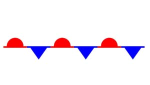
13. Below you will see on the weather map the symbol for a Cold Front is a Blue line with Triangles and a Warm Front is a Red line with half-circles. Label the diagram to show where the cool, dry (cP) air mass and the warm, moist (mT) air mass is in the picture.
1. Along which frontal boundary will thunderstorms develop? Cold
2.Along which frontal boundary will all-day rain occur? Warm
3.Look at the wind arrows on the diagram, do they match the direction of motion you determined in questions 9, d? What direction is that?
Counterclockwise
14. What happens at a Stationary Front? Nothing
15. Search the internet to find out the weather map symbol for a Stationary Front and draw below.
16. Click on this website to see the Current Weather Map. http://www.weather.com/maps/maptype/currentweatherusnational/index_large.html
a. Where is a Cold Front occurring? Kansas
b. Where is a Warm Front occurring? Oklahoma
c. What type of air mass are we currently in? Nothing right now
Part 1. Air Masses
1. http://en.wikipedia.org/wiki/Air_mass Find out what an air mass is.
a. What is an airmass? An airmass is a volume of air defined by its temperature and water vapor content
b. Explain the difference between a “continental(c) ” air mass, and a “maritime(m)” air mass. Continental is dry and Maritime is wet
c. Explain the difference between a “polar(P)” air mass and a “tropical(T)” air mass.
Polar is cold and tropical is wet
2. They describe an air mass by its Moisture content and Temperature, so each air mass has two letters. Name each air mass and describe it by moisture content and temperature.
cP = continental Polar (dry and cold) cT = continental Tropical (dry and warm)
mP =maritime Polar ( wet and cold) mT = maritime Tropical (wet and warm)
Using the map on the webpage, label each of the bubbles below
.
1. Three air masses affect Pennsylvania’s weather the most. Name their air mass symbols and tell me where they come from.
mP from the North East, mT from the South, and cP from the North West
2. Go to the website: http://www.weatherquestions.com/What_causes_high_pressure.htm to find out what causes a high pressure air mass.
a. What causes an air mass to have a high pressure? More atmosphere due to cooling
3. The website http://www.weatherquestions.com/What_causes_low_pressure.htm will help you answer the following question:
a. What causes an air mass to have a low pressure?
Less atmosphere due to atmospheric circulations. Happens along warm-cool boundaries. Air can also be warmed by condensation of water vapor
4. Look at this picture: http://www.physicalgeography.net/fundamentals/images/thermal2.GIF. Does air move from high pressure to low, or low to high? High to Low
Part 2. Global Winds
5. http://ww2010.atmos.uiuc.edu/(Gh)/wwhlpr/global_winds.rxml What are the Global Winds? General Circulation Patterns Label B – L in the diagram below.
Part 3. Coriolis Effect
6. The Coriolis Effect affects Earth’s winds. Read the information at this website to find out about the Coriolis Effect: http://ww2010.atmos.uiuc.edu/(Gh)/guides/mtr/fw/crls.rxml . The video at the bottom will give you a visual of the Coriolis Effect.
a. Click on the “Pressure Gradient” link. What is the direction of the net force between two pressure systems? From high pressure to low pressure.
b. Click on the “High” link. What is a High Pressure Center and what does it mean? Pressure is highest in relation to its surroundings, also anti-cyclone
c. In the video, why does the ball not roll straight across the merry-go-round? The merry- go- round is spinning
d. How is the Earth similar to the merry-go-round? (look at the figure) Both are spinning
e. Wind is an object that is affected by the Coriolis Effect. What happens to winds in the Northern Hemisphere as a results of the Coriolis Effect? Wind defects to the right
7. Use the animation at the following website to help you find out how the Coriolis Effect affects wind: http://www.classzone.com/books/earth_science/terc/content/visualizations/es1905/es1905page01.cfm .
a. Which way does the Coriolis Effect deflect wind in the Northern Hemisphere? It makes it go to the right
Part 4. Pressure Centers and Weather
8. Go to the website listed here: http://ww2010.atmos.uiuc.edu/(Gh)/wx/surface.rxml . Then, find the picture that says “Sea Level Pressure with IR satellite”. Click on this figure to bring up a new window. Click on the button that says “Aminate”. Choose “96 frames”. Answer the following questions:
a. This map shows you isobars and cloud cover. Click on the ? help to explain what an isobar is. Area of shared air pressure
b. Look at the map and find Chicago. Between which two isobars is Chicago? Hot and low
c. Press “Play” on the window, and watch where the clouds travel. Do the clouds tend to be near High pressure centers (H) or Low pressure centers? Low
9. This website will help explain why High pressure centers usually mean good weather, and Low pressure centers usually mean bad weather: http://www.usatoday.com/weather/tg/whighlow/whighlow.htm . Go here and read to discover why this is true, and then answer the following questions:
a. Air descends (comes down) at High pressure areas. Why does descending air not allow for clouds to form? Air warms and can hold back the moisture
b. Air ascends (goes up) at Low pressure areas. Why does ascending air allow for clouds to form? As air cools , water droplets form due to the lack of moisture
c. Use diagram to determine the direction of wind motion. What is the direction around a High pressure system? Clockwise spiral
d. What is the direction around a Low pressure system? Counterclockwise spiral
Part 5. Frontal Boundaries
10. This website will help you to understand a frontal boundary. Read the Introduction at the top and answer the following questions. http://www.phschool.com/atschool/phsciexp/active_art/weather_fronts/
a. What is a weather front? Area where two air masses with different temperatures and densities collide , but do not mix
11. Play the Cold front animation and read the information above to answer the questions below.
a. Which air mass is doing the pushing? Cold
b. What forms when the warm air gets pushed ”up” by the cold air? Clouds and precipitation
c. What kind of clouds form at the frontal boundary? Cumulus and Cumulonimbus
d. What weather is associated with this cloud type? Windy and Stormy
12. Play the Warm Front animation and answer the questions below.
a. Which air mass is doing the pushing? Warm
b. What forms when the warm air rides “up” over the cold air? Clouds and precipitation
c. What kind of clouds form at this frontal boundary? Scattered clouds
d. What kind of clouds are at the very front edge of this boundary? Cumulus
13. Below you will see on the weather map the symbol for a Cold Front is a Blue line with Triangles and a Warm Front is a Red line with half-circles. Label the diagram to show where the cool, dry (cP) air mass and the warm, moist (mT) air mass is in the picture.
1. Along which frontal boundary will thunderstorms develop? Cold
2.Along which frontal boundary will all-day rain occur? Warm
3.Look at the wind arrows on the diagram, do they match the direction of motion you determined in questions 9, d? What direction is that?
Counterclockwise
14. What happens at a Stationary Front? Nothing
15. Search the internet to find out the weather map symbol for a Stationary Front and draw below.
16. Click on this website to see the Current Weather Map. http://www.weather.com/maps/maptype/currentweatherusnational/index_large.html
a. Where is a Cold Front occurring? Kansas
b. Where is a Warm Front occurring? Oklahoma
c. What type of air mass are we currently in? Nothing right now

Part 2, #5
|

#13
|
#15
Weather Systems
Pressure Systems- sinking or rising air, combined with the Coriolis effect, results in the formation of rotating high and low pressure systems in the atmosphere
Low pressure systems- air rises, when air from outside the system replaced the rising air, this air spirals inward toward the center and then upward, clouds and precipitation, winds move counterclockwise
High pressure systems- sinking air moves away from the systems center when it reaches the Earth's surface, clear skies and fair weather, winds move clockwise
Weather instruments
Two important factors in weather forecasting are the accuracy of the data and the amount of available data.
Barometer- measures air pressure
anemometer- measures wind speed
hygrometer- measures humidity
Radiosonde- instrument used for gathering upper-atmosphere data , measures the air's temp., pressure, and humidity
Doppler- speed at which precipitation moves towards or away from a radar station
Station Model- record of weather data for a particular site at a particular time. Advantages: universal language, more info in less space
Isobars- lines of equal pressure
Isotherms- lines of equal temperature
Digital Forecast- created by applying physical principal and math to atmospheric variable and then making a prediction about how these variables will change over time
Severe Weather
Thunderstorms
For a thunderstorm to exist, three conditions must exist
1. There must be an abundant source of moisture in the lower levels of the atmosphere
2. Some mechanism must lift the air so that the moisture can condense and release latent heat
3. The portion of the atmosphere through which the cloud grows must be unstable
Limits to Growth
The air in a thunderstorm will keep rising until:
1. It meets a layer of stable air that it cannot overcome
2. The rate of condensation, which diminishes with height, is insufficient to generate enough latent heat to keep the cloud warmer than the surrounding air
Typical thunderstorms last only about 30 minutes and individual storms are only about 24 km in diameter
Stages
Cumulus Stage
- air starts to rise nearly vertically upwards
–Transported moisture condenses into a visible
cloud and releases
latent heat.
As the cloud droplets
coalesce, they form larger droplets, which eventually
fall to Earth as precipitation
Mature Stage
–As precipitation falls, it cools the air around it which becomes more dense than the surrounding air, so it sinks creating downdrafts.
–The updrafts and downdrafts form a convection cell.
–In the mature stage, nearly equal amounts of updrafts and downdrafts exist side by side in the cumulonimbus cloud.
Dissipation Stage
–The supply of warm, moist air runs out because the cool downdrafts cool the area
from which the storm
draws energy.
–Without the warm air, the updrafts cease and precipitation can no
longer form.
–The dissipation stage is characterized primarily by lingering downdrafts.
Supercells- self-sustaining, extremely powerful severe thunderstorms, which are characterized by intense, rotating updrafts
Lightning is an electrical discharge caused by the friction of falling and rising ice crystals within strong drafts of a cumulonimbus cloud.
Downbursts- are violent downdrafts that are concentrated in a local area and can contain wind speeds of more than 160 km/h.
Tornado- violent, whirling column of air in contact with the ground. Before a tornado reaches the ground, it is called a funnel cloud. Tornadoes are often asssociated with supercells. The air in a tornado is made visible by dust and debris drawn into the swirling column, or by condensation of water vapor into a visible clouds. Forms when wind speed and direction change suddenly with height, a phenomenon known as wind shear. Under the right conditions, this can produce a horizontal rotation near the Earth's surface. A thunderstorm's updrafts can tilt the twisting column of wind from a horizontal to a vertical position. Air pressure in th center drops as the rotation accelerates. The extreme pressure gradient between the center and the outer portion of the tornado produces the violent winds associated with tornadoes. The Fujita tornado intensity scale classifies tornadoes according to their path of destruction, wind, speed, and duration. The scale ranges from F0, which is characterized by winds of up to 118 km/h, to the violent F5, which can pack winds of more than 500 km/h. Most tornadoes do not exceed the F1 category. Only about one percent ever reach the violent categories of F4 and F5. –While tornadoes can occur at any time or place, some places are more conducive to their formation. Most tornadoes form in the spring during the late afternoon and evening, when the temperature contrasts between polar air and tropical air are the greatest. Tornadoes occur most frequently in a region called “Tornado Alley,” which extends from northern Texas through Oklahoma, Kansas, and Missouri.
•Tropical cyclones are large, rotating, low-pressure storms that form over water during summer and fall in the tropics. •The strongest of these cyclonic storms are known in the United States and other parts of the Atlantic Ocean as hurricanes. •Tropical cyclones thrive on the tremendous amount of energy in warm, tropical oceans.•This latent heat from water that has evaporated from the ocean is released when the air begins to rise and water vapor condenses.
•Rising air creates an area of low pressure at the ocean surface.
•The cyclonic rotation of a tropical cyclone begins as warm air moves toward the low-pressure center to replace the air that has risen.
Tropical cyclones require two basic conditions to form:
•An abundant supply of very warm ocean water
•Some sort of disturbance to lift warm air and keep it rising
–Tropical cyclones move according to the wind currents that steer them.
–In the deep tropics, tropical cyclones are often caught
up in subtropical high-pressure systems that are
usually present.
–They move steadily toward the west, then eventually turn poleward when they reach the far edges of the
high-pressure systems.
There, they are guided by prevailing westerlies and begin to interact with midlatitude systems
–Tropical cyclones usually begin as disturbances that originate either from the ITCZ or as weak, low-pressure systems called tropical waves.
•The Saffir-Simpson hurricane scale classifies hurricanes according to wind speed, air pressure in the center, and potential for property damage.
Tornado Bio
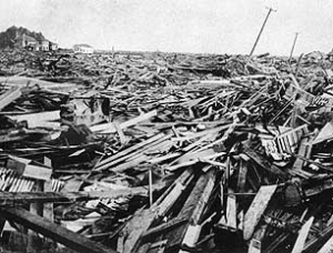
The deadliest tornado in history happened in the Manikganj district of Bangladesh on April 26, 1989. The path of destruction was a mile wide and ten miles long. Two cities were destroyed and estimated 1,300 were killed and 12,000 were injured. 80,000 people were left homeless from the destruction. Bangladesh frequently has high-death tolls from tornadoes (up to F4 or F5 levels) with more than 6 tornadoes a year. Yet, there is still little protection for the people, despite having the most tornadoes per year of any country outside of the US. They have high population density, poor building structure, and no warning systems, leaving the people helpless against a tornado.

Hurricane Bio
Bangladesh is also home to the deadliest hurricane recorded in recent history. On November 12, 1970, Hurricane Byola hit Bangladesh and West Bengal. The hurricane itself wasn't huge ( it was recorded at a level 3), but the surge from the sea after the hurricane was devastating. Whole villages and crops were wiped out and entire islands were flooded.. An estimated 300,000- 500,000 people were killed by this storm, also because of the high population density, poor building structure, and no warning system. Bangladesh is a poor country and they can't afford insurance or proper protection from natural disasters such as hurricanes and tornadoes.
